|
|
||
|
||
| |||||||||||||
Documenting MicroclimateIn addition to the effects of large scale regional climate patterns, conditions on your site are affected by local features that affect temperature, moisture and lighting. The most influential of these features are slope (steepness), aspect (direction), exposure, canopy coverage (light penetration) and air drainage (frost pockets).
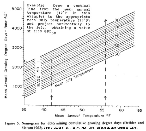
You may decide to modify your zones based on what you learn about microclimate. As you read about these factors, note which monitoring methods you prefer for each. Monitoring site temperature with a max-min thermometerMonitoring site temperature is a long term process that involves using one or more max/min thermometers to record daily temperature extremes. A reason for measuring temperature at one or more locations of your site is to estimate GDD if that information for your area is not published. This information is useful, also, if your site differs considerably in temperature or elevation from the nearest weather station from which GDD values are based. Additionally, by recording temperatures of several areas, you may find microclimatic differences in the zones you designated in [2.2] According to Carl Davies, who was a forward thinking agroforestry expert in the Northeast, a difference in average temperature of 2.5 F between a hilltop and the frost pocket at the bottom of the hill would result in a difference of as much as 450 GDD over the growing season. Differences of this scale could significantly effect your crop selection. The figure below from his paper Microclimate Evaluation and Modification for Northern Nut Tree Plantings(1) illustrates a method for estimating GDD based on average annual and average July temperatures for a site. To use the chart, locate your mean (average) annual Fahrenheit temperature at the bottom (35-65), draw a vertical line up until you reach the diagonal line which represents your mean July temperature (60-80). From that point, draw a horizontal line to the left to determine your mean annual growing degree days on the 400-5000 scale.  Go to the GDD Resources Box in the previous section to download a pdf version of the entire Davies article, Microclimate Evaluation and Modification for Northern Nut Tree Plantings
In Microclimate Evaluation and Modification for Northern Nut Tree Plantings, Davies also explains how to use the nomogram to estimate growing degree days using weather station and site temperature data from only a few months. This paper explains how GDD, Frost Free Days (FFD) and windbreaks effect nut tree growth and provides additional methods for estimating growing season temperatures for particular sites. [Download entire article] SlopeFew potential forest farming sites in the Northeast are on flat ground. Slopes affect crop performance by influencing runoff and erosion potential, soil moisture content, soil composition, air drainage and the duration of exposure to direct sunlight. Ginseng, for example, is typically found in the wild on relatively steep slopes because they are better drained than flat land. Shagbark hickory is generally found on well-drained slopes, whereas shellbark hickory prefers moister flat valley bottoms. There are several different methods for measuring slope (the angle of a hill). One is the use of a forester’s instrument called a clinometer. Another is the “rise over run” method, and the third is simply the “eye ball” estimate. ClinometerA clinometer is a simple forester’s instrument used to measure either the slope of a hill or the height of a tree, in either % slope or in degrees. For instructions in how to use it see the Vegetation/Terrain Field Equipment Procedures, weblinked below. Rise-Over-Run Method
The percent slope is distance B divided by distance A expressed as a percentage, or: % Slope = (B/A) x 100
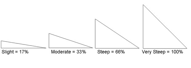
This method reveals that a 45° angle is the same as 100% slope. Eye Ball EstimateFor most purposes it is sufficient to describe your slope in relative terms – slight, moderate, steep or very steep. Remember that a 100% slope (very steep) is equal to a 45° angle. See the figure below for examples. 
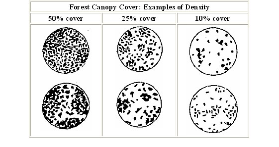
AspectAspect is the compass direction that the slope of a hill faces. Generally, north and northeast facing slopes get less total sunlight during the course of a day than south or southeast facing slopes, which are consequently hotter and dryer. This can have a major impact on NTFC compatibility. For example, ginseng typically grows best on north or northeast facing slopes because it prefers cooler, moister conditions. Aspect can be determined either by standing on the slope with a compass or from a topographic map. The compass direction from top to bottom is the aspect. If you have a topographical map of your site you can mark slope aspects in your workbook and map without going into the field. Primary (N,E,S,W) and secondary (NE,NW,SE,SW) cardinal directions are sufficient. If you are disappointed that your slopes generally face the wrong direction for particular crops, go into the field and look for smaller raised or depressed areas that face a more favorable direction for crops you are interested in growing. Canopy Cover – Light PenetrationForest Farming, by definition, is a system for growing NTFCs under the canopy of an established forest or wood lot. Hence, forest farming crops grown in the mid or understory are exposed to full or partial shade. This is an important difference between forest farming and most conventional agriculture. NTFCs tend to be shade adapted, low light requiring or at least low light tolerant species. Light influences plant growth directly because of its influence on photosynthesis. It has an indirect effect due to its influence on temperature, soil moisture, and humidity. For example, light affects forest cultivated mushrooms because even partial sunlight can cause heating and drying of substrate logs. “Canopy cover” refers to the amount of the open sky blocked out by the leafy overstory of forest trees, as seen from below. It can be expressed most simply as percent canopy cover. Sophisticated hemispherical photography combined with computer image analysis can be used to accurately quantify canopy cover at different times of year. A rough visual estimate, however, is sufficient for most forest farming purposes.
Air Drainage – Frost PocketsThink of the adage, “warm air rises”, and the converse “cold air sinks”. In the outdoors this is particularly true at night and can have significant effects on the performance of forest farming crops especially if they are growing near the limits of their winter cold hardiness. As Carl Davies pointed out, a difference in elevation between a hill top and adjacent valley bottom of only a hundred feet or so can result in a nighttime temperature difference of 2.5 degrees F and a difference of more than 400 GDD over the course of a growing season. You can predict the existence of cold air pockets from a topographic map, but the best way is to walk your site frequently during all times of year.
References1) A Guide to Agroforestry in British Columbia (Small Woodlands Program of British Colombia). Illustration developed by R. Terry and G. Chillinger. Published by the Society of Economic Paleontologist and Mineralogist in the Journal of Sedimentary Petrology 25(3): 229–234, September 1955. |
|||||||||||||
| << Previous : Next >> |
| Cornell Cooperative Extension ©2006 |

|
